
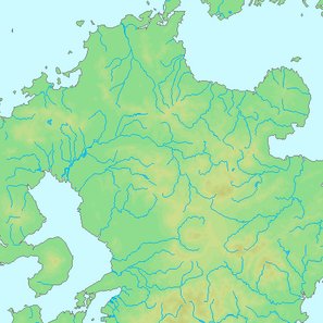
The rather clumsily-named 昭和28年西日本水害 (Showa 28 nen Nishi Nihon Suigai - Western Japan Flood of 1953) occurred in Fukuoka, Oita, Nagasaki and Kumamoto between June 25 and 29 of that year and resulted from over 1,000mm of rain, in 1,001 fatalities, and in 450,000 houses flooded and one million people affected. The majority of the damage came from the flooding of Shirakawa (those interested in specifics can find them at the link - Japanese).
A friend of mine who was a young woman at the time and working at what is now Tsuruya (all of downtown was flooded, and she had trouble getting home) once told me that the rain did not seem particularly heavy, but that the amount of debris swept downstream built up at the bridge pilings, creating dams that not only forced the water over the banks but collapsed the bridges, adding to more debris subsequently aimed at the next bridge. Damage was particularly severe in the area between Ryujin Bridge and Kokai Bridge next to Kumamoto University, and the high concrete banks there are a legacy of response to the disaster. (A monument to the disaster stands at the foot of the Kokai Bridge on the Toroku side.)
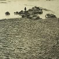
I was thinking about this today when I saw the large amount of debris accumulated on Shirakawa bridge pilings, something I'd never seen and due to the large amount of debris generated by the quakes. Fortunately, engineering technological advances have enabled the pilings to be spaced further apart, basically eliminating the threat of another such dam and of bridge collapse. If you're near Shirakawa, look at the pilings on the upstream side and thank the engineers for their ingenuity.
-- William