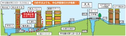
William With rainy season on our doorstep figuratively, let's hope it doesn't end up on our doorstep literally. The figure shows that the areas adjacent to the banks of Shirakawa are lower than the river and how flooding (kōzui、洪水 or hanran、氾濫) might be expected. The building on the left, City Hall, for example, may experience flooding up to five meters; my side of the river will fare better at one meter, with water flowing on to Lake Ezu. Shirakawa has been widened, but Kumamoto remains an alluvial plain prone to flooding. Kumanichi has some eye-opening photos at this link:
http://www.qsr.mlit.go.jp/kumamoto/site_files/file/river/sonotanokaigi/siryou1-8kai.pdf
and Kumamoto City provides an "entertaining" interactive flood hazard map (click site to see how far underwater it could go):
https://hazard.kumamoto-city.jp/sphone.html