Joe Tomei here with FFF as we go by the Prefectural University of Kumamoto and introduce two places.
The first is nice little cafe just across from the uni, behind the AU store on the corner called Cafe Puu (https://www.instagram.com/puucafe/) The couple does sandwiches and curry lunches, along with coffee. Parking is a bit troublesome, but if you are at the uni or the Red Cross hospital, it's just across the street.
The second place is Po Po Po Shokudo (https://www.instagram.com/popopo2021.1/), which is 600 meters down from from the university on Joshidai dori, across from the Higo Ginkgo parking lot which you can use and get a parking card if you eat there. I had passed it a number of times and it had a high school bunkasai feel with red and white plastic tableclothes and foldup tables and chairs, and wondered what the deal was, so gave it a try and I have to say, it is off the hook. The owner is a former pâtissier and all the food there is made with great attention to detail. For the lunches that have rice, you can get a onsen tamago (soft boiled egg) And on Sundays, he does ramen (very well, I might add). It's often full up, so you want to get their early.
I'd be remiss if I didn't mention Moisson (https://www.instagram.com/moisson.kumamoto/), a bakery across from the West gate of the University. Where you go if Puu and Po po po are full.
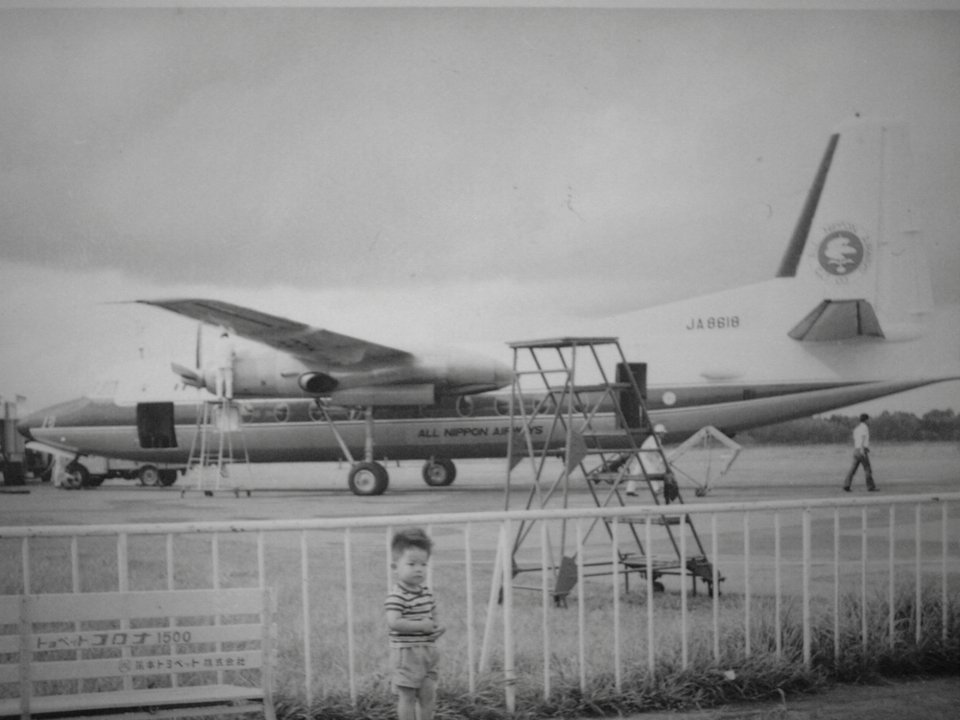
A little note about the history of the area, this was where the airport was in Kumamoto from 1960 until 1969, when construction started on the Aso-Kumamoto airport, which was completed in 1971. The field was known as Kengun field and as one might expect, the location of that airfield was intially related to military matters, with the Jieitai base formerly a Mitsubishi airplane factory. In fact, not only was the airfield the launch point for Tokutai/Kamikaze flights against Okinawa at the end of the war, it also was the jumping off spot for the raid at Yontan airfield in Okinawa, shortly after Okinawa campaign started. At the time, the area was originally known as Takamiya-so, but came to be called Kengun, expanding from the original Kengun, probably because of the military industries in the area. Looking for information, I came across this 1964 picture of a plane and a boy who is probably my age at the time and so could still be living in Kumamoto. (link below)
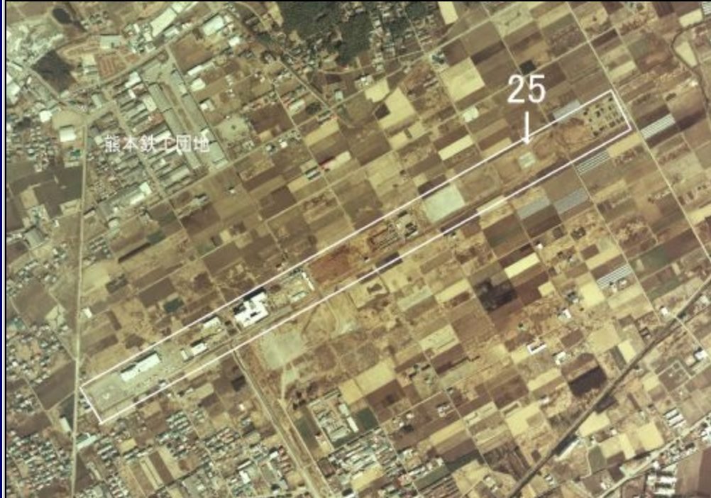
One page (link 4) had picture of where the airfield was, which I've included. Matching up with Google maps, this is the area that begins at the new Starbucks, up the Kokutai doro until the Mister Donuts on the corner. You can still find a few of the concrete structures that were part of the airfield on the left side of the street. Also, on the photo is marked 熊本鉄工団地 [Kumamoto Ironworks Complex], which is still an ongoing concern, with the name changed to Shin Nippon Stainless [新日本ステンレス工業鉄工団地].
Because FB only allows 2 links, the historical information is here if anyone wants to follow up
1. https://en.wikipedia.org/wiki/Raid_on_Yontan_Airfield
2. https://wjon3117.medium.com/operation-gi-the-japanese-attack-on-yontan-airbase-okinawa-d1fa340b0e3d
3. https://flyteam.jp/photo/3064736
4. http://hikokikumo.net/a8502-01-Kengun-F86F-000.htm