515

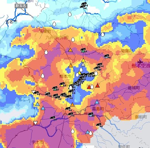
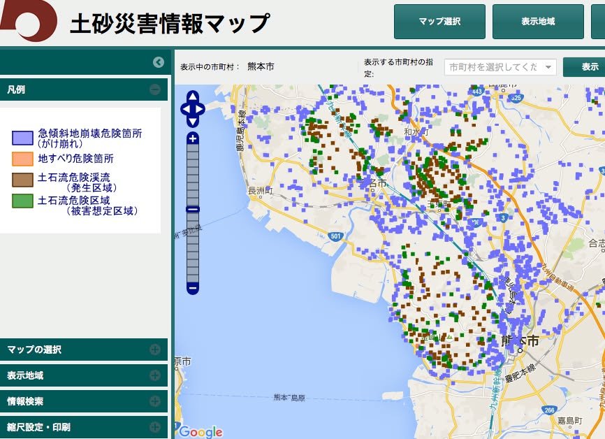
This map is hard to make out (particularly if you don't read Japanese) but it shows the current situation in the Kumamoto City area. Many of the camera marks on the map are on the Shirakawa River, so if you know where the Shirakawa is, that may help you make sense of the map. The red triangles indicate waterways that have reached the flood level. (They may not have flooded yet, but they are very close to doing so.) One of them is the little waterway that runs by the Nishikigaoka Park in Kengun -- a favorite jogging spot of mine. As far as I can tell, major rivers such as the Shirakawa are still OK but smaller waterways are having trouble handling the sudden surge. Be careful around such places.
http://www.river.go.jp/kawabou/ipGaikyoMap.do?areaCd=89&prefCd=4301&townCd=4301201&gamenId=01-0701&fldCtlParty=no
-- Kirk

2016-06-20 23:22 JST
600

If you are in Kumamoto now, you don't need radar to tell you that the rain is intense. Nonetheless, here's that confirmation just the same.
-- Kirk
http://www.river.go.jp/kawabou/ipRadar.do?areaCd=89&prefCd=&townCd=&gamenId=01-0706&fldCtlParty=no

2016-06-20 23:02 JST
2008

A reminder about the livecams maintained on the main bridges along Shirakawa through Kumamoto in case you are curious about the river level but don't feel like walking out there to check for youself. (Trust me: you don't.) http://www.qsr.mlit.go.jp/kumamoto/bousai/kasen_live/kasen_live01.html

2016-06-20 22:20 JST
2062

Kumamoto should do what Hiroshima has done: Put evacuation notices on an easy to understand map. Right now, Hiroshima only has a couple of places where people are being told to get ready to evacuate (the blue suitcases). If there were evacuation recommendations (a green ! mark) or evacuation orders (a red !!! mark) they would appear on the map in the same way. Even if one couldn't read Japanese, one could easily learn to check for any of the three marks in your area and then take appropriate action.
http://www.bousai.pref.hiroshima.jp/hdis/sizi/
-- This rant has been brought to you by Kirk

2016-06-20 21:44 JST
000

I'm trying to post information about various evacuation orders and recommendations but Kumamoto Prefecture makes this sort of information very difficult to confirm on the web. The page they provide is
https://www.anshin.pref.kumamoto.jp/osirase/index.cgi?type=1001
but even if you read Japanese the information is hard to interpret and clearly incomplete. Yahoo is much better.
http://crisis.yahoo.co.jp/evacuation/43/
One problem with this Yahoo page, however, is that you can't run it through an automatic translator, like Google translate. So, if you don't read Japanese, you need to get the help of someone who does.
At any rate, a lot of evacuation notices have been issued. I wish I could give you better information but I don't have time to try to translate everything. All I can say now is that, if you are unsure about the situation in your area, you should probably ask someone nearby for advice.
-- Kirk

2016-06-20 21:27 JST
100

As of 5:30 this evening, the people of Mifune are being told to prepare for possible evacuation.
06月20日18:32配信
御船町 避難準備
6月20日17時30分町内全域(避難指示・避難勧告地域を除く)に避難準備情報を発令しました。各地域の避難所は、御船地区(御船中体育館)●滝尾地区(カルチャーセンター)●水越地区(旧水越小体育館)●七滝地区(七滝分館)●上野地区(上野保育園)●田代東部地区(田代東部公民館)●田代西部地区(北田代公民館)●木倉地区(木倉小体育館)●高木地区(御船小体育館)●小坂地区(小坂小体育館)です。
https://www.anshin.pref.kumamoto.jp/osirase/view.cgi?log_id=572

2016-06-20 21:11 JST
501

An evacuation notice (hinan kankoku -- not an order but a recommendation) has been issued for Kikuchi City. The Japanese text says it was issued at about 4:30 PM but then sent out (on the internet?) at 6:16 PM. The Japanese text also provides the names of evacuation sites that are available.
06月20日18:16配信
避難勧告発令
こちらは菊池市です。
以下の地区に避難勧告を発令しました。
避難勧告 発令 06月20日16時30分 土砂災害(特別)警戒区域等 避難所は菊池市福祉会館、七城公民館、旭志公民館、泗水公民館、水源交流館、やまびこ体育館、旧龍門小学校、旧迫水小学校体育館
https://www.anshin.pref.kumamoto.jp/osirase/view.cgi?log_id=571

2016-06-20 21:05 JST
632

I just came across this map, which provides detailed visual information about areas that are at risk for landslides. This information doesn't change; it merely shows the locations of areas that are deemed to be at risk because of their physical characteristics. This is something that you might refer to if you are considering driving at night, during heavy rain, and are wondering if the area you are driving through might be risky.
http://sabo.kiken.pref.kumamoto.jp/website/sabo/kasho/
There are four colors:
1) Blue: Areas with steep inclines (nearly cliffs) that are susceptible to landslides (gakekuzure);
2) Orange: Areas that are not as steep as the blue areas but, nonetheless, are susceptible to mudslides and landslides (jisuberi);
3) Brown: Gorges along which a mudslide might flow (dosekiryu);
4) Green: Areas into which a mudslide flow (from a brown area) might wind up (dosekiryu higai sotei)
When in doubt, err on the side of safety!
-- Kirk

2016-06-20 20:56 JST
301

As I pointed out yesterday, "ground loosening" isn't what farmers do to get their fields ready for planting -- it means that there is an elevated risk of landslides. Note too that flooding is an additional possibility. To see the details for your area, click on the following link:
http://www.jma.go.jp/en/warn/349_table.html
Kirk

2016-06-20 20:22 JST
100

This map, which was issued at 3 PM today, shows areas that are thought to be vulnerable to landslides (shown in orange). The horizontal red lines indicate areas affect by the earthquakes. The pdf from which this screenshot was taken can be found here:
http://www.jma.go.jp/jp/dosha/349_index.html

2016-06-20 20:15 JST

JAL has launched a discounted service between major Honshu airports and major Kyushu airports at a price of 5,400 yen per flight during the period between June 17 and October 29. The bad news for Kumamoto residents is that ticket purchases must originate overseas; however, for those with family or friends visiting (or, like me, with children who are returning home for summer vacation), the offer is worth a look. More info in very stilted English is at the link.
http://press.jal.co.jp/en/release/201606/003841.html
Jun 17, 2016 JAL Launches New Domestic Fare for Overseas Visitors to the Kyushu Region
Tokyo June 17, 2016: Japan Airlines (JAL) decided to launch a new domestic fare - “oneworld®YOKOSO/Visit KYUSHU Fare” for overseas visitors in order to stimulate travel demand from overseas to the Kyushu region.

2016-06-20 12:48 JST
9013

‘Earthquake sickness’ still felt by many in Kumamoto:The Asahi Shimbun
KUMAMOTO--An increasing number of residents here are complaining of “earthquake sickness,

2016-06-20 07:24 JST
1101

I posted earlier this evening about warnings that have been issued for Kumamoto. I'd like to add two little footnotes.
1) The areas that have received warnings about possible landslides resulting from heavy rain are near Minamata and Hitoyoshi (both in the southern part of the prefecture).
2) The English phrase that is used is "ground loosening" while that in Japanese is 土砂災害 (dosha saigai). I've checked in various online dictionaries and this is usually translated "landslide disaster":
http://ejje.weblio.jp/content/土砂災害
Sure, if the ground loosens up you are more like to get a landslide but "loose ground" sounds a lot less alarming than "landslide disaster." It seems very odd to me that a phrase that sounds more like a euphemism than a warning would be used in regard to a possible landslide.
-- KIrk
P.S. English page is here:
http://www.jma.go.jp/en/warn/349_table.html
Japanese page is here:
http://www.jma.go.jp/jp/warn/349_table.html
One more thought: I think "ground loosening" is probably a translation of "地盤がゆるい" (jiban ga yurui). I've heard this expression on the news but it's usually followed by warnings about what that means: You need be wary of 土砂災害 (landslide disasters).

2016-06-19 23:26 JST

We've had some heavy rain in the past 24 hours. According to NHK at 9 AM this morning, 25,533 people in Yatsushiro, 1410 people in Minami Aso and 1311 people in Nishihara Mura were advised to evacuate.
http://www3.nhk.or.jp/news/html/20160619/k10010561441000.htm
A news video on the following news site reports that Ushibuka (in Amakusa) got over 83 milimeters (3.2 inches) of rain in just one hour.
http://www.news24.jp/articles/2016/06/19/07333048.html
The map showing Kumamoto in red is a screenshot I just took from the web. Click on it to find information in English about warnings that have been issued for your corner of Kumamoto.
http://www.jma.go.jp/en/warn/
I hope the heavy rain is not accompanied by a big aftershock. Even without aftershocks, steep inclines can be dangerous at times like this.
Also, an elderly man in Kagoshima is reported to have lost his life today after falling into a surging irrigation ditch.
Take care!
-- Kirk
Japan Meteorological Agency | Weather Warnings/Advisories

2016-06-19 21:09 JST
905

Honda Re-Opens Kumamoto Plant After It Was Damaged in the Earthquake - News
The Honda Two Wheelers plant at Kumamoto, Japan was severely damaged in the earthquake that hit the prefecture on April 15-16, 2016. Honda says that it is now satisfied with the safety levels and has resumed production at the plant. Although, it will be mid-August before production hits at full capa...

2016-06-19 14:15 JST
203

Kumamoto drives demand for ready-made formula
Interest in ready-made liquid baby formula, which came in handy in the areas affected by the Kumamoto Earthquake, has been growing.

2016-06-19 11:03 JST
605

This is a lengthy discussion of how to rebuild Kumamoto with many comparisons to the recovery effort still in progress in the Tohoko region.
http://www.the-japan-news.com/news/article/0003015150
Rebuilding homes after the Kumamoto Earthquake
Two months have passed since a major earthquake struck Kumamoto Prefecture. More than 80,000 buildings have been damaged or destroyed there. Some 10,000 people are still living in evacuation shelters. Now, governments face the urgent task of reconstructing houses to allow victims to restore their da...

2016-06-19 07:11 JST
3608

Here's another article on the attempt to save the Iida-maru Gokai Yagura.
http://www.asahi.com/ajw/articles/AJ201606170052.html
Workers rush to save Kumamoto castle’s stone support wall:The Asahi Shimbun
KUMAMOTO--Emergency work to shore up a corner of Kumamoto Castle’s Iida-maru five-story turret, whic

2016-06-19 00:02 JST
503

Residents in quake-hit city of Kumamoto irked over having to foot bill to dispose of appliances...
As quake-hit areas in Kumamoto Prefecture work to dispose of debris, residents in the city of Kumamoto are complaining that the costs of discarding electri

2016-06-18 09:19 JST

William wrote today about plans to fix the Iidamaru Yagura. William explained that repairs would be accomplished "by wrapping the entire turret in a steel frame to allow three cantilever beams to be inserted into the foundation of the turret, relieving the weight from the stone walls."
This video report from NHK includes an image of how that steel frame with wrap around the turret.
-- Kirk
http://www3.nhk.or.jp/news/html/20160616/k10010558851000.html
熊本城 崩れそうなやぐらの倒壊防止工事を公開 | NHKニュース
一連の地震で下の石垣が大きく崩れ、残った石でかろうじて支えられている熊本城の「飯田丸五階櫓」の倒壊を防ぐための工事が16日、報道各社に公開さ…

2016-06-17 23:55 JST