Archive of the Kumamoto International Facebook group, 2011–present.

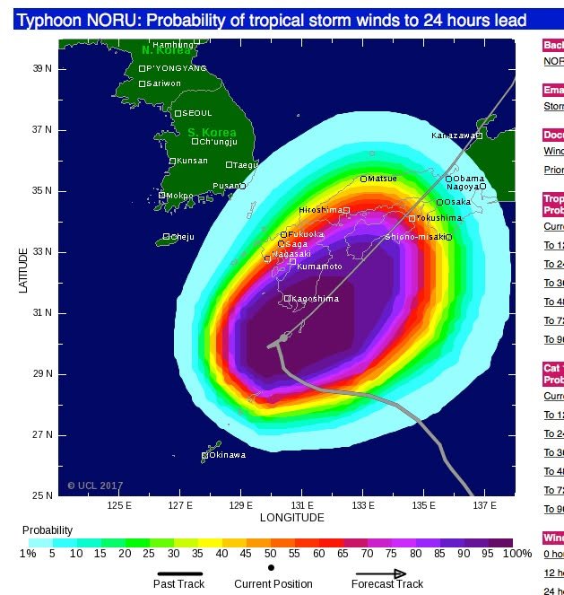
According to TropicalStorm.com, the anticipated path of the storm has shifted to the east. That's good news for us. The site still says that we're likely to get some strong winds, but I don't think they take topography (the Aso mountains, etc) into account when they generate these maps. JMA is still warning of strong winds and rain in our area so it's probably premature to plan a picnic for this afternoon but, as Joe suggested, you may want to take advantage of the relatively mild weather while you can. -- Kirk
2017-08-06 10:56 JST

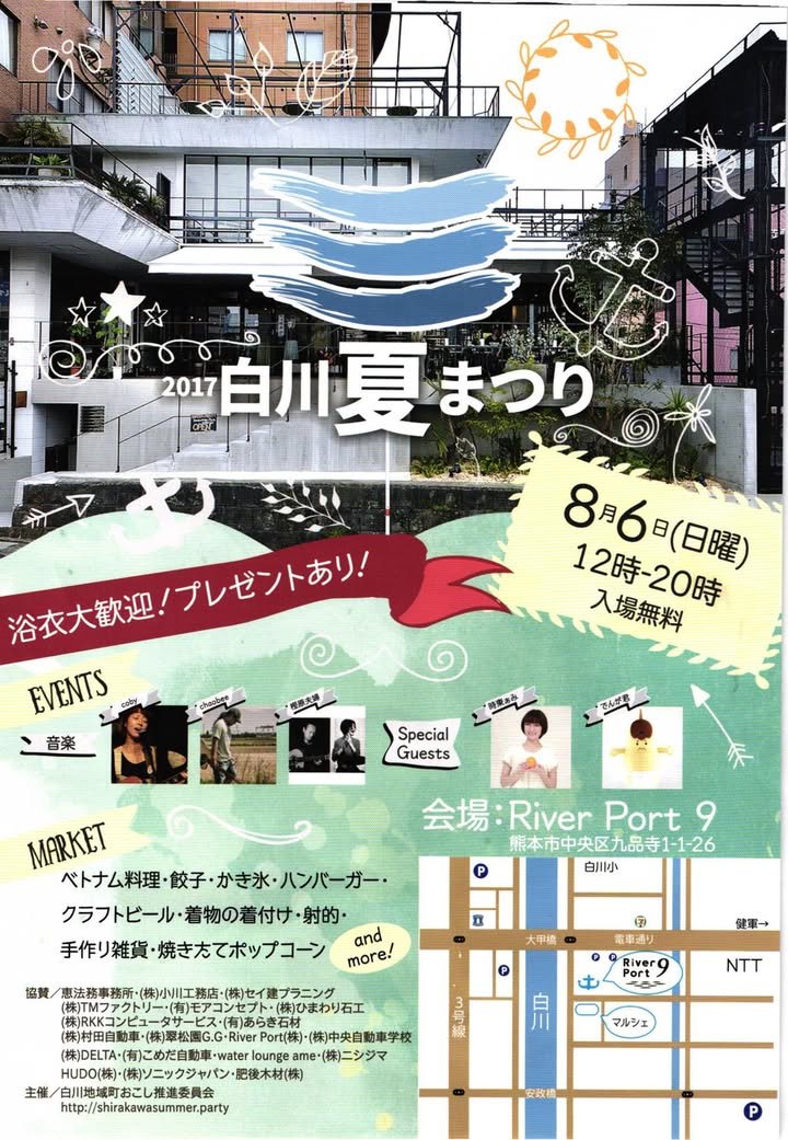
Well, since Typhoon Noru-chan decided to go somewhere else, folks may want to go River Port 9, on the far side of Taiko bashi (the bridge that carries the densha), and check out the Shirakawa Summer Matsuri. -- Joe

2017-08-06 08:31 JST

This Japanese website provides a chronological guide to fireworks events in Kumamoto. I should have posted this earlier, as a couple of major events have already been held. There's still lots more to come, though. I realize that the timing of this post may be a bit odd, with the typhoon approaching, but I thought I should get the information out before I forget.
If you're unable to read Japanese, I suggest that you use the translation function on the Google Chrome browser. I just tested it and found that, while place names are not always rendered correctly, the translation is good enough to function as a heads up about upcoming opportunities.
-- Kirk

熊本県の花火大会2017まとめ | 花火大会ガイド2017
2017年(平成29年)に「熊本県」で開催される花火大会(33ヵ所)の日程、打ち上げ数、開催場所などを一覧にまとめています。

2017-08-05 22:54 JST

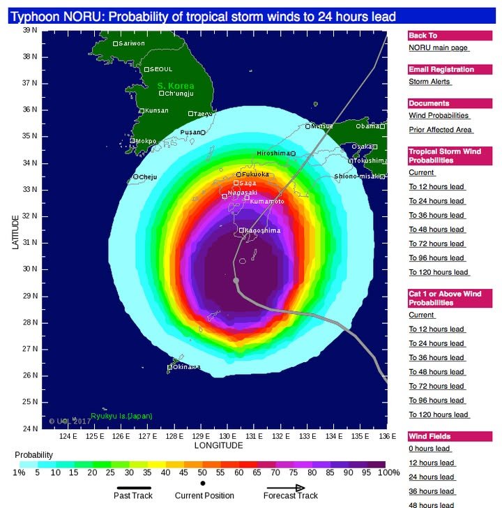
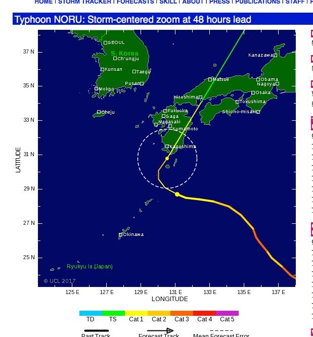
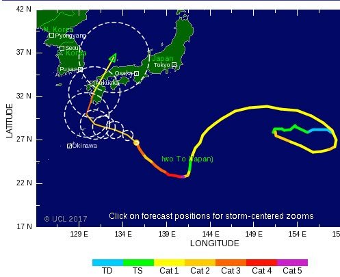
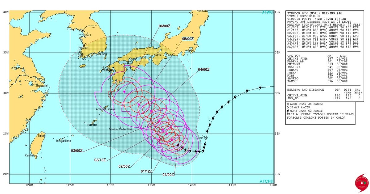
According to http://www.tropicalstormrisk.com, all regions of Kumamoto are quite likely to be experiencing tropic storm winds (see key in second image) in about 24 hours. Over the years, my experience with this site (TropicalStorm.com, that is) is that actual events are sometimes considerably less severe than predicted but, importantly, are sometimes more severe. Since weather and climate are chaotic systems (that is, systems that are highly sensitive to initial conditions), prediction is never an exact science. It's better to err on the side of caution.
Also, I heard on TV that it's possible that wind and rain will pick up just as the system is about to leave our area. This is because cyclones spin counterclockwise in the northern hemisphere and so air and moisture from the southwest may be sucked in just after the system passes overhead. At any rate, I'd like to encourage everyone to take this seriously -- assume the worst, and hope for the best.
-- Kirk
P.S. I also heard on TV that the arrival of the storm will coincide with high tide. This could cause a dangerous storm surge in coastal areas. Please plan ahead so that you don't wind up in the wrong place at the wrong time.

2017-08-05 13:50 JST

According to TropicalStormRisk.com, our outlook has improved a bit. It looks like the path of the storm has shifted to the southeast. Good news for us, however, is bad news for Kagoshima. The web site is predicting that the cyclone will hit Kagoshima Sunday evening and then move north rather rapidly.
-- Kirk
http://www.tropicalstormrisk.com

2017-08-04 18:29 JST

Years ago, I was in my hometown near Los Angeles waiting for my wife outside a Japanese supermarket and fell into conversation with an older woman distributing fliers for a shogatusu celebration, and it turned out she had emigrated from Kashima several decades previously. She was shocked to hear my stories of how Kashima had developed since then (huge shopping malls!)
Kumanichi has an article on Kumamoto diaspora in LA who have organized a group called "Kumamoto Reconstruction Assistance Hinokuni Festival IN LA Executive Committee" 「熊本復興支援火の国まつりIN LA実行委員会」to hold a festival coinciding with the Hinokuni Festival to raise funds for earthquake relief.
It's a small world. Hope the approaching typhoon will not adversely affect the festivities. Enjoy, everyone! - William

“火の国まつり”LAでも 熊本市出身者ら企画 復興支援に - 熊本日日新聞
「火の国まつり」を冠したイベントのチラシを持つ安藤みちよさん(実行委員会提供) 熊本市の中心市街地で4~6日に開かれる「第40回火の国まつり」に合わせ、熊本から遠く離れた米ロサンゼルスでも現地時間の5日、火の国まつりを冠したイベントが初めて...

2017-08-04 16:52 JST

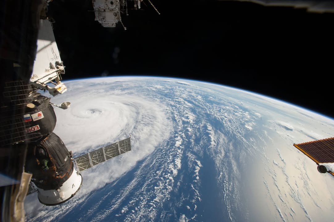
The caption to this photo from the NASA site is sufficient: "NASA astronaut Randy Bresnik photographed Super Typhoon Noru in the Northwestern Pacific Ocean on August 1, 2017, as the International Space Station passed overhead. He shared images of the massive storm on social media, writing, 'Super Typhoon #Noru, amazing the size of this weather phenomenon, you can almost sense its power from 250 miles above.'" - William
https://www.nasa.gov/image-feature/space-station-flyover-of-super-typhoon-noru

2017-08-04 11:20 JST

If you are a fan of either the Japanese science-fiction anime television series "Neon Genesis Evangelion" or of the art of Japanese sword making you may want to check out the traveling exhibition in progress at the Kumamoto Prefectural Art Museum. Here is the first paragraph from an article about the exhibition when it began in Paris:
"The Japan Foundation held the Evangelion and Japanese Swords Exhibition in Paris from April through June, 2014 after the exhibition enjoyed a great popularity in Japan, and also organized the event in Madrid in commemoration of the 400th anniversary of Japan-Spain exchanges from July 5 through September 28, 2014. In this exhibition where master craftsmen across Japan challenged the world of Evangelion: New Theatrical Edition, a popular animated film series, the swords and other sharp-edged weapons replicated with traditional skills such as the Lance of Longinus, Bizen Osafune and Magoroku Sword which are important items of the story as well as 20 Japanese swords and other items created by craftsmen who got inspirations from Evangelion and its characters were mainly shown together with 5 famous and traditional Japanese swords, accessories, the real-sized sculpture of Eva 01 and character image panels."
http://www.wochikochi.jp/english/special/2014/09/the-evangelion-and-japanese-swords-exhibition-from-the-perspective-of-a-spanish-manga-lover.php
-- Kirk
http://www.kab.co.jp/special/evangelion_tousyou/

「ヱヴァンゲリヲンと日本刀展」が熊本へ!2017年7月27日(木)より熊本県立美術館 分館で開催!

2017-08-04 10:34 JST

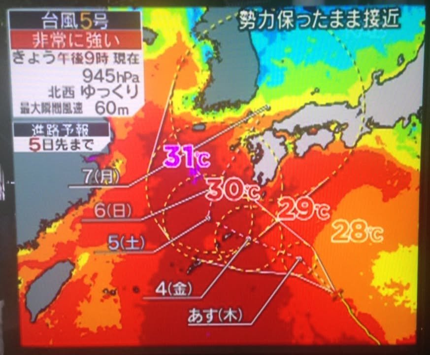
This is an image from a TV show (News Station) that I recorded last night. The point is that ocean temperatures around Kyushu are high and that this means that typhoon is likely to remain strong as it approaches. As I understand it, heat is the fuel that makes cyclones go so there is concern that global warming is giving rise to increasingly powerful storms.
-- Kirk

2017-08-03 19:51 JST

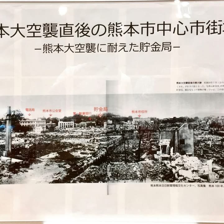
The image shows some of the devastation that Kumamoto City suffered as a result of intense bombing in 1945. Buildings that were well known at the time are marked in red. The Shiyakusho (City Hall) is the building marked on the far right. If we could see the castle, that would help us recognize this scene as being Kumamoto City but the castle had already been destroyed in the Seinan Civil War of 1877 and did not get rebuilt until 1960.
This image is from the following blog:
http://nasushoten.blog.jp/archives/8486354.html
I'm not sure if the exact same image is part of the display currently on view at City Hall (the downtown Shiyakusho) but I assume that many similarly interesting photos are. Here's a Japanese web page from Kumamoto City's site about the display:
http://www.city.kumamoto.jp/hpkiji/pub/detail.aspx?c_id=5&type=top&id=5917
It says that the panel display will be at the Shiyakusho until August 9th and then move to the Higashi Kuyakusho (East Ward Kuyakusho) until the 17th.
-- Kirk
http://livedoor.blogimg.jp/nasushoten/imgs/d/a/da985415.jpg

2017-08-03 16:10 JST

According to TropicalStorm.com, NORU (Typhoon No. 5 in Japan) is scheduled to arrive in about 4 days. It's a strong system and may be a category 2 or even 3 cyclone when it hits Kyushu. That's a good deal stronger than the typhoon we experienced earlier this year, the one that did a fair amount of damage. On the other hand, though stronger than the previous one, the angle of approach should reduce the impact that we feel here in Kumamoto.
http://www.tropicalstormrisk.com
-- Kirk
P.S. Here's the address of a previous post of mine in which I explain what it was about the angle of approach that increased the damage last time:
https://www.facebook.com/Kumamotoi/photos/a.129499733790134.25925.123734781033296/1511645678908859/
http://www.tropicalstormrisk.com

2017-08-03 10:39 JST

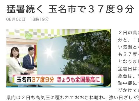
Tamana (about an hour's drive north of Kumamoto City) had the highest temperature in Japan today. As you can see in the image, the temperature was 37.9 C or just over 100 F. This was the second day in a row for Tamana to be at the top of the list of "hot spots" in Japan. -- Kirk
http://www3.nhk.or.jp/lnews/kumamoto/5005710641.html

2017-08-02 22:20 JST

Minamata survivor to attend conference on treaty to prevent mercury pollution | The Japan Times
A survivor of Minamata mercury poisoning disease will visit Switzerland next month to attend the first conference of signatory states to an international t

2017-08-02 21:34 JST

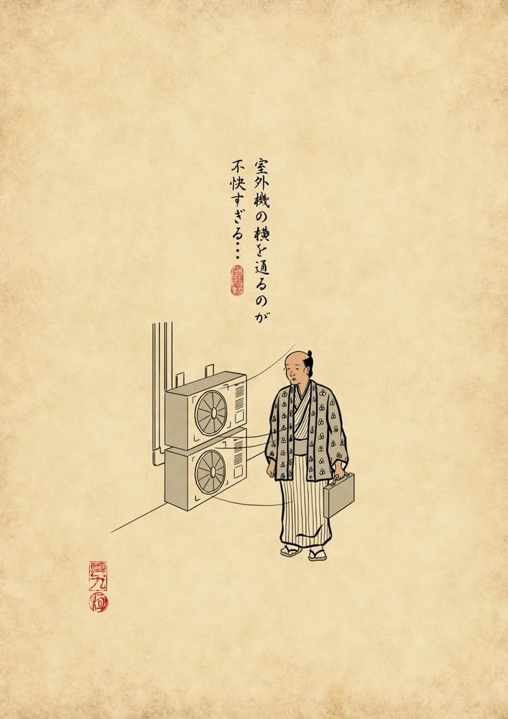
William here. Kirk-san posted yesterday about the heat index, which factors in such parameters as humidity and wind. The approaching typhoon seems to be kicking the breeze up a bit, but above a certain temperature, wind has no effect on human cooling. I just ventured outside, and it felt like this:

2017-08-02 13:01 JST

With the hot weather we've been having, I'm frequently tempted to search on the web to try to find the the peak temperature for Kumamoto. Well, I think I've found a reasonably good site. It's in Japanese but numbers are numbers so that shouldn't be too much of a problem:
http://www.jma.go.jp/jp/amedas_h/today-86141.html
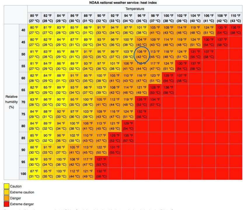
Today's high (near Kumamoto Castle, where the measurements are taken) was 36.8 C (98.2 F), with a relative humidity of 51%. If you're interested, you can take these numbers and plot them on a heat index chart like the one to be found here
https://en.wikipedia.org/wiki/Heat_index
to get confirm what your senses are telling you . . . it's REALLY hot!
-- Kirk

2017-08-01 21:17 JST

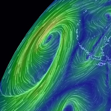
From the Kumamoto International Desk of Meteorology and Psychedelic Music (merged due to budget cuts): Seriously, cue up your favorite mind-altering song and open this link. - William
earth :: a global map of wind, weather, and ocean conditions
See current wind, weather, ocean, and pollution conditions, as forecast by supercomputers, on an interactive animated map. Updated every three hours.

2017-08-01 17:12 JST

"A fully fledged Sumo Run event with about 1,000 runners is planned for Kumamoto Prefecture in October to raise funds for victims of the disaster."
If you have a few moments, check out the video on the article page. I think it will make you smile. :)
-- Kirk
http://www.asahi.com/ajw/articles/AJ201707310023.html

‘Sumo’ fun run thunders across Fukuoka park for quake victims:The Asahi Shimbun
FUKUOKA--Thundering footsteps of sumo wrestlers running together could be enough to trigger another

2017-08-01 17:00 JST

Okay, so Typhoon #5, who had no idea where he wanted to go (first west, then east, then west again, then south, then north, now west again) seems to be heading our way, and it appears we'll finally meet around Sunday or Monday. It's not particularly powerful in terms of cataclysmic events but bears watching. (Second photo: bears watching.) - William

2017-08-01 13:51 JST

An unexploded incendiary bomb was discovered yesterday during waterworks construction near Kasegawa close to the Claire Mall. It was apparently dropped during the American raids that occurred coincidentally almost 72 year ago to this day and is a meter in length and 40 cm in diameter. As the risk of explosion by moving the bomb is high, the SDF will destroy it by a controlled explosion on 8/5; houses within 150 meters of the site will be evacuated and traffic restricted.
That might be fun to watch. More info and a map can be found at the link. - William
https://this.kiji.is/264922423918822908?c=92619697908483575

不発弾、5日に信管除去 熊本市が約40世帯に避難指示へ - 熊本日日新聞
熊本市不発弾処理対策本部の会議で関係機関に協力を呼び掛ける本部長の大西一史市長(中央)=同市役所 熊本市東区画図町で見つかった不発弾に関し、市は31日、爆発を引き起こす恐れのある信管を8月5日に除去すると発表した。除去地点から半径150メー...

2017-08-01 11:45 JST

This article includes the following paragraph:
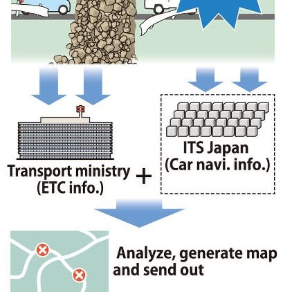
"The push to create the system came from the 2011 Great East Japan Earthquake and tsunami and the 2016 Kumamoto earthquakes. During the 2011 disaster, the central and municipal government sent out information separately about the roads each body respectively managed, and it wasn't until 12 days after the initial earthquake that the government summarized all the information so a supply route carrying aid to the disaster-hit areas could be established. Additionally, in the case of the Kumamoto earthquakes, because the main shock occurred in the early hours of the morning, it was impossible to confirm the status of the roads from above in the darkness. It took roughly 16 hours until the central government could issue its first report on damage to the road system."
-- Kirk
https://mainichi.jp/english/articles/20170730/p2a/00m/0na/001000c

Gov't develops data system to grasp road conditions for faster disaster response - The Mainichi
The Ministry of Land, Infrastructure, Transport and Tourism (MLIT) has teamed up with an NPO to create a system that tracks the movements of cars during disasters to grasp road conditions and shorten the time taken to set up rescue and supply lines for emergency responders.

2017-08-01 07:56 JST