Kirk here. It's raining again and a "watch" (注意報; chuui hou) is in effect for the whole prefecture. I suspect that calls for "evacuation" (避難; hinan) of certain areas will be made again this weekend. So, in preparation, I'll be making some posts to help you understand the risks you may face and whether or not you need to seek shelter somewhere else.
First, I put "evacuation" in quotes above because the original Japanese is a bit more ambiguous than the English term, "hinan." In Japanese, it is possible to "hinan" at home, if your home is safe enough. So, when "evacuation" comes up in English news and announcements about how to respond to the extreme rain, you might want to interpret it as "go to or make sure you are already in a place that is safe."
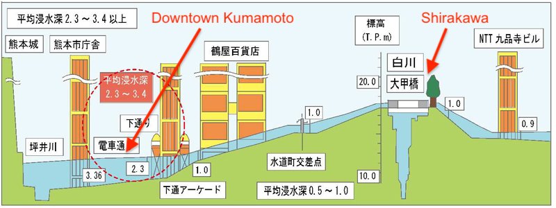
Now, to determine whether you are in a safe place or not, you need to refer to a hazard map. I'll share links to such maps in a subsequent post but in this post I'd like to point out that flooding risk can be a little counterintuitive. In other words, you can be a pretty far from a river but still face significant risk of flood. Take the image below. This is one that I learned about from William but today I've taken it from a different source and added some English. Here's the Japanese source:
https://www.qsr.mlit.go.jp/tateno/shirakawa/tokusei.html
As you can see, downtown Kumamoto (Shimotori, etc) is many meters lower than the Shirakawa River. There would have to be an extreme event for downtown Kumamoto to be flooded. This doesn't happen often but the following article says that in the 1953 flood, the downtown area was covered in 2.5 meters of water -- which would have been way over the head of the tallest NBA basketball player:
https://www.asahi.com/articles/ASN6P6RGQN6PTLVB007.html
So, the moral of the story is that proximity to a river is not the only thing to consider. You also need to know how low your area is in relationship to the river. For that, I'm planning to post information about so-called "hazard maps" that you can check online.