This image is from the following site: http://www.tropicalstormrisk.com
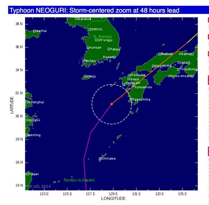
2014-07-07 21:15 JST 2014 This image is from the following site: http://www.tropicalstormrisk.com ↗ View original post on Facebook For a link to the original post on Facebook, open this page on a computer. Reactions: 0 · Comments: 0 · Shares: 1 ← 2014-07-07 11:38 JST 2014-07-07 21:16 JST → Around this time … 2014-07-08 09:37 JSTHere's the forecast for the next five days. According to this, it looks like we will begin to experience the typhoon tomorrow (Wednesday, July 9th) but that it will be closest to Kumamoto from 3 AM on the 10th (Thursday) to 3 AM on the 11th (Friday).http://www.jma.go.jp/jp/typh/14085.html気象庁 | 台風情報 2014-07-07 21:21 JST"In Kyushu, parts of Nagasaki, Kumamoto and Kagoshima prefectures got more than 300 mm of rain from Sunday to Monday, prompting landslide warnings in some areas."http://www.japantimes.co.jp/news/2014/07/07/national/typhoon-heading-toward-okinawa/Typhoon heading toward Okinawa | The Japan Times 2014-07-07 21:16 JSTSuper-typhoon Neoguri approaches Japan's Okinawa islands 2014-07-07 21:17 JSTRed alert for Japan’s Kyushu island as landslide loom, … 2014-07-07 21:23 JST"Evacuation of 87,000 people was announced in Kumamoto prefecture in southwestern Japan because of the risk of flooding, said Monday the NHK TV company. The evacuation of the entire population of Amakusa district, which includes the same-name city and its neighboring towns, was announced In Kumamoto Prefecture, according to RIA Novosti reports.This was caused by the increased risk of flooding due to heavy rains. Only for one hour 70 millimeters of rain fell in the region on Monday morning. In Kumamoto, Kagoshima, Nagasaki prefecture and at Kyushu island 250 millimeters of rain fell yesterday. The Main Japanese Metrological Office warns of increased risks of floods, landslides, mountain avalanches. Kumamoto prefecture reports of landslides in residential areas."http://voiceofrussia.com/news/2014_07_07/Evacuation-of-87-000-people-due-to-threat-of-flooding-in-Japan-media-7246/Evacuation of 87,000 people due to threat of flooding in Japan - media 2014-07-07 21:15 JSTThis image is from the following site: (this post) 2014-07-07 11:38 JSTThis came from the city:"Tropical Cyclone Information TY 1408 (NEOGURI) is comming close to Kyushu(Kumamoto)June 11th , 2014A heavy rain advisory has been issued for the following areas: kumamoto Pref.Tropical Cyclone Information TY 1408 (NEOGURI) is comming close to Kyushu(Kumamoto).Please note more Tropical Cyclone information.Japan Meteorological Agency HPhttp://www.jma.go.jp/en/typh/If you have any concerns, feel free to contact the Kumamoto City International Foundation (Kumamoto City International Center).(TEL) 096-359-4995 (9a.m.〜8p.m.)"I appreciate the hard work of the city officials who put this information out in English. I think, though, that we also need an automated system in English (and other languages) that runs in parallel to the Japanese e-mail warning system.Japan Meteorological Agency | Tropical Cyclone Information 2014-07-07 09:20 JSTThis table is the best source I have been able to find so far for information about weather-related warnings. One problem, however, is that it doesn't say anything about the evacuation recommendations for Amakusa. It sure would be nice to have the most important information neatly packaged in one place.http://www.jma.go.jp/en/warn/349_table.html 2014-07-07 08:05 JSTI won't try to explain what each of the colors and the chicken wire mesh at the top mean in detail because, frankly, the prefecture's explanation doesn't make a lot of sense to me. I can say two things, however. Red is the worst level and it means either that rivers have reached flooding level (or perhaps are already overflowing) or that there's a danger of landslides or both (both are listed as meanings in the key so this too is confusing). Places with chicken-wire mesh over the red have been told to evacuate (though the Japanese explanation does not state this clearly).A good information science specialist needs to help the prefecture fix their system. The national government's system also has serious problems, such as putting out emergency information in pdf files that must be clicked upon. Still, one positive thing I can say about the prefecture's map is that it does give you a general idea of where the situation is the worse.http://www.bousai.pref.kumamoto.jp/GmnDsp.exe?M100A0S0N1P0 2014-07-07 07:40 JSTHere's the current warning levels for Amakusa (via Google translate):Kumamoto Prefecture 06 minutes announced 06 pm July 7, 2014 Amakusa region ● Kamiamakusa [Continue] heavy rain, flood warning, thunderstorm advisory ● Amakusa [Continue] heavy rain, flood warning, lightning, strong wind warning ● Reihoku-machi [Continue] heavy rain, flood warning, lightning, strong wind warning http://www.anshin.pref.kumamoto.jp/rireki/saigai/430031.htmlHere's the information for Kumamoto City:"● Kumamoto Kumamoto [Continue] heavy rain warning, flood watch [warning from the alarm] thunderstorm advisory"http://www.anshin.pref.kumamoto.jp/rireki/saigai/430000.htmlThe automatic translation is a bit garbled it gives you a basic idea. 2014-07-07 07:24 JSTGoogle translation of an e-mail I received:"Amakusa Disaster Risk Management Division I have issued an evacuation advisory to the entire city Amakusa 7 4:00 July In addition, I established the Amakusa disaster response headquarters at the same time In Amakusa region, and it is with heavy rain once in '50 Please have to evacuate to a safe place, such as a second floor in a house or shelter, designated as soon as possible. Contact: Amakusa Disaster Risk Management Division Phone 0969-22-1111"The situation in Amakusa was on NHK's national news this morning. Here's the Japanese message (for which no URL is listed):"天草市防災危機管理課7月7日4:00に天草市内全域に避難勧告を発令しましたまた、同時刻に天草市災害対策本部を設置しました天草地域では、50年に一度の大雨となっています速やかに指定の避難所、または家屋内の2階などの安全な場所へ避難へしてください。お問い合わせ先:天草市防災危機管理課 電話0969-22-1111"