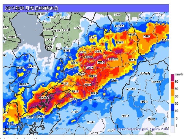
Kirk here. First of all, please note that the radar image is from 2019, not today. But, there have been warnings that this kind of thing may happen here early tomorrow. Here's a Claude translation of one report:
--- start translation ---
[BREAKING] "Half-Day-Ahead Forecast for Stalled Heavy-Rain Bands" Issued for Kumamoto and Nagasaki Prefectures
Authorities warn that bands of torrential rain could form, sharply raising the risk of a major rain disaster.
■ Kumamoto Prefecture: from the early hours of the 24th through early afternoon
■ Nagasaki Prefecture: from late night on the 23rd through early afternoon on the 24th
--- end translation ---
This was published at 17:40 today (Tuesday, the 23rd) here:
https://news.yahoo.co.jp/articles/2c4631f629a55109554e94fcdc5d0e566e627dfc
Here's a note from Claude about the key meteorological term (線状降水帯):
The Japanese term in this report is 線状降水帯 (senjō kōsuitai), which the news media usually translate literally as a "linear precipitation band." That phrase is accurate but doesn't convey much to most English speakers, so here's the idea in plain terms: storms keep forming and passing over the same area, one after another, for hours at a time. Instead of moving on the way ordinary rain does, the heavy rain effectively stays parked over one place and keeps pouring down. That's what makes it dangerous — not a passing shower but a downpour that lingers and adds up fast, which is how serious flooding and landslides happen. The Japan Meteorological Agency began using this term widely around 2014 as a way to warn people quickly, and a "half-day-ahead forecast" means they're flagging the risk roughly twelve hours before it might develop, so there's time to prepare.