671

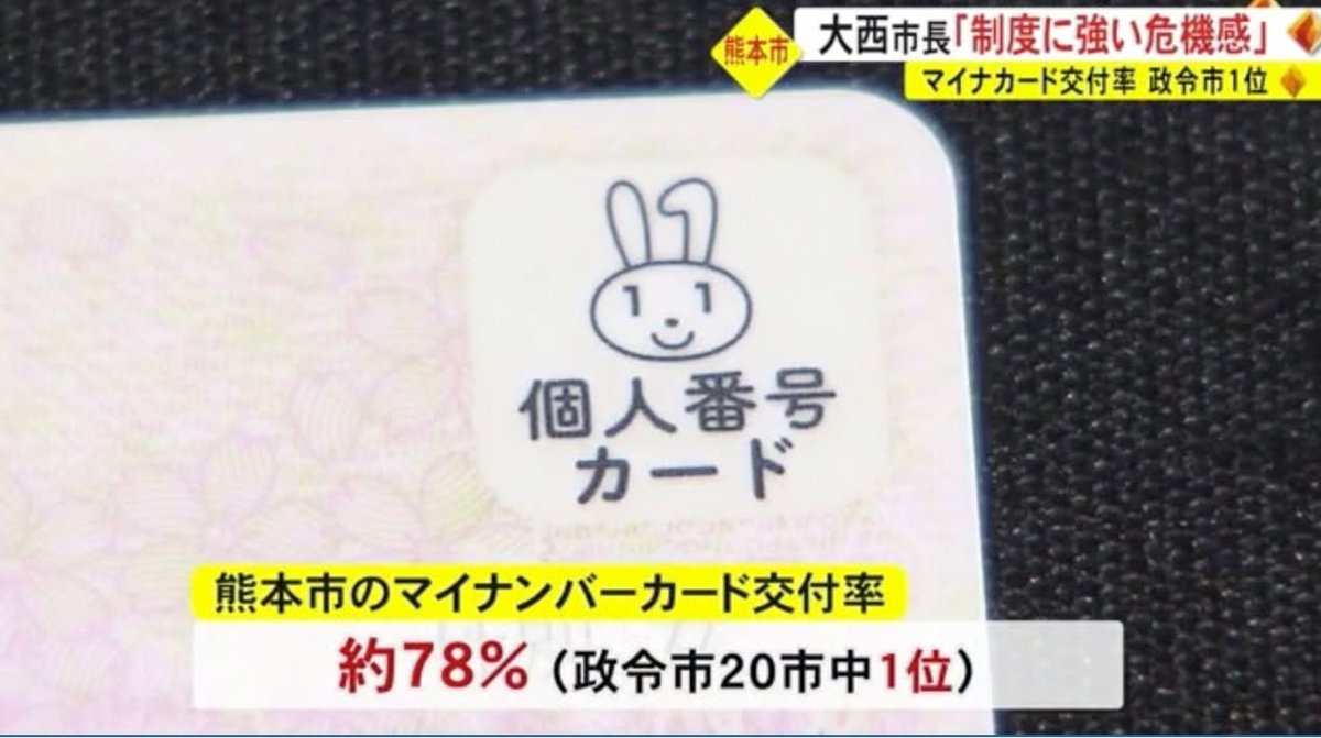
Kirk with some news about "my number cards" (maina cards). Kumamoto City has achieved the highest adoption rate (78%) of 20 ordinance-designated (seirei shitei; 政令指定) cities. Moreover, "maina cards" have made it possible to get certain documents (residence registries [juumin-hyou], etc.) for only 10 yen each a local convenience stores. This has led to over half of all such documents in Kumamoto being procured at convenience stores rather than at ward offices. Personally, I've found this to be very convenient and you can't beat that 10 yen price! :)
But, because the national government failed to adequately protect private information (see English article below) the mayor has decide the put the convenience store service on hold (Japanese article). In our family, we just received word that we need to submit a juumin-hyou to register a new vehicle so this means we'll have to make a special trip to a ward office and pay a good deal more. :(
Sources:
About Kumamoto (in Japanese):
https://news.yahoo.co.jp/articles/3354a0ace75e0ff348342f6d625ca1cd6520d075
About the problems with the cards (in English):
https://www.japantimes.co.jp/news/2023/07/07/national/my-number-card-investigation/

2023-07-08 22:28 JST
601

Kirk with a link to the hazard map I promised yesterday:
https://disaportal.gsi.go.jp/maps/
The URL for yesterday's post, in case you missed it:
https://www.facebook.com/Kumamotoi/posts/pfbid08SZY7mHyFABUhZn3emryDSxd1RV6p1EXXy5DERf97V9ZhBzVGW33tZKDKRHczpvUl
I think this is the best hazard map interface I've seen so far. You can choose one type of risk (flood, landslide, storm surge, etc.) and display that separately or choose several to display simultaneously (overlapping) as in the example image I have made for this post. As far as I can tell, the projected depths of water are worst-case scenarios but I couldn't find an explanation of whether that is once in a hundred years or what. I did find a note indicating that, in extreme circumstances, depths might be even greater than those projected.
I hope this will help you decide whether or not you are in a area that is risky enough to warrant moving to another location when evacuation "orders" are issued. Please check out your situation before you forget so that you don't need to look for the link to the hazard map in an emergency.

2023-07-08 10:44 JST
2822

Sean here -
Some then and this morning comparison pics (before today's rains). Unfortunately, the pics really don't do justice to how far the lake overflowed its banks. But still amazing, none the less.

2023-07-07 21:34 JST
2043

(Claire) Uto and it’s uk link came up again! Link on the comments. It’s a lovely place for a stop and stretch of your legs in June.

2023-07-07 13:13 JST
1101

Kirk here. It's raining again and a "watch" (注意報; chuui hou) is in effect for the whole prefecture. I suspect that calls for "evacuation" (避難; hinan) of certain areas will be made again this weekend. So, in preparation, I'll be making some posts to help you understand the risks you may face and whether or not you need to seek shelter somewhere else.
First, I put "evacuation" in quotes above because the original Japanese is a bit more ambiguous than the English term, "hinan." In Japanese, it is possible to "hinan" at home, if your home is safe enough. So, when "evacuation" comes up in English news and announcements about how to respond to the extreme rain, you might want to interpret it as "go to or make sure you are already in a place that is safe."
Now, to determine whether you are in a safe place or not, you need to refer to a hazard map. I'll share links to such maps in a subsequent post but in this post I'd like to point out that flooding risk can be a little counterintuitive. In other words, you can be a pretty far from a river but still face significant risk of flood. Take the image below. This is one that I learned about from William but today I've taken it from a different source and added some English. Here's the Japanese source:
https://www.qsr.mlit.go.jp/tateno/shirakawa/tokusei.html
As you can see, downtown Kumamoto (Shimotori, etc) is many meters lower than the Shirakawa River. There would have to be an extreme event for downtown Kumamoto to be flooded. This doesn't happen often but the following article says that in the 1953 flood, the downtown area was covered in 2.5 meters of water -- which would have been way over the head of the tallest NBA basketball player:
https://www.asahi.com/articles/ASN6P6RGQN6PTLVB007.html
So, the moral of the story is that proximity to a river is not the only thing to consider. You also need to know how low your area is in relationship to the river. For that, I'm planning to post information about so-called "hazard maps" that you can check online.

2023-07-07 09:54 JST
901

(Claire) Hi, GattoNero, an Italian restaurant with an Italian chef , Yamaga way in Kahoku, will be holding their second Olive oil tasting/seminar on July 29th. It will be in English with Japanese translation. My sister in law went last time and really enjoyed it. You can message them through Instagram in English, Italian or Japanese or phone them in those languages too for more information. 0968 32 4333

2023-07-06 13:27 JST
100

Kirk here. Heavy rain has been coming all too frequently in recent years:
Elementary school in Kumamoto Pref. marks 3rd anniversary of deadly floods | NHK WORLD-JAPAN News
Children at an elementary school in a village in Kumamoto Prefecture, southwestern Japan, have marked the third anniversary of deadly flooding that hit the region.

2023-07-05 19:07 JST
840

Kirk here. Judging from the caption on this picture, this damaged section of Highway 28 would be about here:
https://goo.gl/maps/sm7J4WxvkgjJYxLh9
https://kumanichi.com/articles/1096921
熊本県央で記録的大雨 県内に線状降水帯2回発生 益城町・木山川など氾濫、山都町・金内橋が崩落 |熊本日日新聞社
 熊本県内は3日、梅雨前線に暖かく湿った空気が流れ込み、県央で記録的な大雨となった。気象庁は、局地的な豪雨をもたらす線状降水帯が熊本地方などに発生したとする「顕著な大雨に関する気象情報」を2回発表。山都....

2023-07-05 12:49 JST
800

Kirk again. This came to me in an e-mail from the International Center:
----- start quote -----
Heavy rains are predicted to arrive in Kumamoto. Evacuation shelters will open from 17:00 on July 4th (TUE).
When preparing to go to a shelter, please remember to bring with you the necessities such as food, water and prescription drugs.
※ When the shelter closes , please remember to take with you any garbage that you accumulated.
※ It is very dangerous for people to evacuate during severe the rain and or cold. You should plan accordingly trying to avoid leaving after dark.
(1)List of evacuation shelters:
   Please check kumamoto City Disaster Prevention Information Portal
https://city-kumamoto.my.salesforce-sites.com/#
Please note more information.
Japan Meteorological Agency:https://www.jma.go.jp/jma/indexe.html
NHK World:https://www3.nhk.or.jp/nhkworld/
Kumamoto International Foundation
4-18 Hanaba-cho Chuo ward Kumamoto 860-0806
096-359-2121
[email protected]
----- end quote -----
You can set this page to display in English by clicking on the Google translate button at the upper right corner of the screen. Unfortunately, this only displays in Japanese and you have to choose "英語" for English but once you do that it works pretty well.
As I have written before, I doubt many of you will actually need to evacuate anytime soon. But, if your situation does call for it, the Kumamoto City Disaster Prevention Information Portal URL provided by the International Center should prove to be very useful. It tells you which centers have been opened, whether or not they are full, etc.

2023-07-04 22:23 JST
1200

Kirk here with an inquiry from Julie, who got some well-deserved recognition last year for her long-standing practice of picking up after other people every morning. Well, now Julie, who does so much for other people, needs a little help from anyone who might have some Kiwi (New Zealand) currency that they would be willing to exchange for yen. She has some students who will be traveling to New Zealand and would like to help them get used to the actual currency before they go.
If you are already connected to Julie, please contact her directly. If not, I think a comment to this post should be enough for her to get in touch with you. Thanks! :)
https://www.facebook.com/Kumamotoi/posts/pfbid02FTusLKMfS7NhbPEXe3XvzouqnhDV1v7sGHgunwNu7zPfBCm5vqofKC8NuQiQLCdvl
毎朝ごみ拾い、YOUは何者? 5種類の分別袋にマジックハンド 英語講師のウオーターマンさん 「生徒が掃除」するJAPANに驚き|熊本日日新聞社
 熊本市内で毎朝「自転車に袋を積んだ外国人女性がマジックハンドを使い、雨の日も風の日もごみ拾いをしています」との情報が、同市の70代男性から「SNSこちら編集局」(S編)に寄せられた。周囲の注目を集めるこの女...

2023-07-04 17:50 JST
100

Kirk here giving the rain a break (I hope it gives us a break) and posting in the "stuff I didn't know or had forgotten" category. Today's bit of unknown or forgotten information pertains to the caption written for the photo you see with this article:
"A masked GSDF member stands by NEWS electronic warfare vehicles at Camp Kengun in the city of Kumamoto. (Mainichi/Yoshitake Matsuura)"
NEWS stands for "network electronic warfare systems." The systems are designed to "jam “enemy radio waves in an integrated manner” and “establish information superiority over potential adversaries.”" Sure hope these systems never need to used! 😕
https://www.thedefensepost.com/2022/03/30/japan-electronic-warfare-unit/
https://mainichi.jp/english/articles/20230628/p2g/00m/0na/045000c
Japan reveals guidelines to urge firms to develop defense technology - The Mainichi
TOKYO (Kyodo) -- The Japanese government on Wednesday revealed guidelines for the development of its defense technology with the aim of urging private

2023-07-04 17:26 JST
1330

Kirk with a follow-up about "evacuation orders."
This Japan Times article includes the following sentence:
"In the city of Kumamoto, 368,000 residents were ordered to evacuate on the morning of July 3, after water levels rose in the Shirakawa river, which runs through the area."
The population of Kumamoto City that is published in the June edition of the Shisei dayori (市政だより) is 736,245 so 368,000 is about half of the whole city. Obviously, it would have been an absolute disaster (a "secondary disaster") if all of those people had tried to evacuate. So, it's NOT the case that "368,000 residents were ordered" to evacuate. Rather, that many people live in areas where they were to evacuate if their particular circumstances (proximity to a river or steep incline, etc.) warranted it. So, as I have written in the past "evacuation order" doesn't mean "everyone go to your nearest evacuation center."
See this previous post of mine for more details:
https://www.facebook.com/Kumamotoi/posts/pfbid02yPoXdKo4NM8SrYZenpepcwNJx7onhRqyG1Qn6QyU8L7QSRMfhZNLHGVeBjFew8wpl
I think that, in preparation for future disasters, the Japan Times and other English-language newspapers should explain this properly.
Now, one might imagine that half of the city's population was ordered to evacuate but not everyone obeyed. That, however, wasn't the assumption of the Hindustan Times. They published an article with the following headline:
Heavy rains trigger havoc in Japan's Kumamoto, over 360,000 evacuated
https://www.hindustantimes.com/world-news/japan-rains-heavy-rains-trigger-havoc-in-japans-kumamoto-over-360-000-evacuated-101688383115802.html
There really WOULD have been havoc if over 360,000 had actually evacuated.
Now, of course, I recognize that few foreigners in Japan rely on the Hindustan Times for information about disasters here but, nonetheless, I think it's an interesting example of how the multilingual telephone game of "confusing government proclamation --> media report --> media report based on a media report" can go off the rails, so to speak.

https://www.japantimes.co.jp/news/2023/07/03/national/kyshu-floods-rain-evacuation/
As heavy rain pounds Kyushu, evacuation ordered for 360,000
The Meteorological Agency warned of torrential rain and thunder continuing across the region through around Tuesday noon and called on residents to be on alert for mudslides and flooding.

2023-07-04 14:56 JST
500

Kirk here. The image you see is of a road near the Kiyama River (the one that overflowed) in Mashiki-machi Tahara. The RKK video has some other amazing scenes (such as a violently surging Gorogataki-gawa in Yamato-cho) that you may want to check out.
『橋が崩壊』『寺が倒壊』『道路が冠水』など大きな被害  益城町と山都町で【7月観測史上最大の雨】  熊本 | 熊本のニュース|RKK熊本放送
熊本県内では、3日の午前6時半ごろに熊本地方と阿蘇地方で線状降水帯が発生し、降り続いた大雨で各地で大きな被害が出ています。昨夜から激しい雷雨となった県内、熊本空港の情報カメラには稲光が映っています。梅…

2023-07-03 21:38 JST
400

Kirk again. I just found this NHK World page that has many of the images and videos I've already introduced but with text in English.
Weather officials warn heavy rain may continue in Kyushu until Tuesday | NHK WORLD-JAPAN News
Developed rain clouds are hanging over southern Kyushu, bringing intermittent downpours to Kagoshima Prefecture.

2023-07-03 19:09 JST
400

Kirk here with a damage report. A temple (浄恩寺) in Mashiki-machi that was damaged by a landslide. The priest had evacuated already so no one was hurt.
https://www3.nhk.or.jp/news/html/20230703/k10014116571000.html

2023-07-03 18:58 JST
4762

Sean here - reporting closer to home. Ezuko @ noon
Stay safe and appreciate the fact that it is people, not the earth needing to be saved.

2023-07-03 13:57 JST
1961

Kirk again. My classes have been cancelled for today due to the rain so I have a bit more time to provide updates. If you are anywhere near a river (or if you are just curious) you should know about the following website:
https://www.river.go.jp/kawabou/pc/tm?zm=11&clat=32.743302174991605&clon=130.7627320289612&fld=0&mapType=0&viewGrpStg=0&viewRd=1&viewRW=1&viewRiver=1&viewPoint=1&ext=0&ofcCd=11009&itmkndCd=4&obsCd=22
As an illustration, I've added screenshots of the Shinkawa Bridge, which is on the Iwatogawa, in Mashiki-machi. The data indicates that the water level is higher (!) than the levee. You can see what that looks like in the live photo. Even if you don't read Japanese, this map should help you learn about the current status of the riiver(s) near you.
Oh, one last bit of advice: Please confine your curiosity about what a river looks like at the moment to what you can see via a remote camera. I've heard quite a few media reports about people who went to take a look at a river during a rainstorm and didn't live to tell about it.

2023-07-03 12:46 JST
1902

Kirk here with a link to an NHK page showing parts of Kumamoto Prefecture that have flooded. All of the videos seem to have been submitted by citizen videographers.
【投稿映像 タイムライン】熊本で線状降水帯 各地の状況は | NHK | WEB特集
【NHK】活発な前線の影響で熊本県では3日朝に線状降水帯が発生して非常に激しい雨が同じ場所に降り続き、災害の危険性が急激に高まって…

2023-07-03 11:07 JST
1031

Kirk here. Some evacuation "orders" have been issued for some parts of Kumamoto due to the heavy rain. I put the word "orders" in parentheses because, even if an order has been issued in your area, it doesn't necessarily mean that you must go to a shelter. It depends on the specifics of your location within the area with such an order. We discussed this a lot last year. Please see the following for more information:
https://www.facebook.com/Kumamotoi/posts/pfbid0mEk2qer2ZuYEe9nk2crL4SYrd8HsDFnW1xziMw6yb6o2bpDWSYhH5wYNfteLg9dTl
I would like to stress, though, that heavy rain should be taken seriously and you need to know about the vulnerabilities of your particular area in order to decide how to stay safe. When in doubt, check with people living nearby.
A list of areas for which such orders have been issued can be found on the following page (in Japanese, but tools like Google translate can be used to render it in English):
https://crisis.yahoo.co.jp/evacuation/43/

2023-07-03 09:11 JST
200

Kirk here. The caption says "Shinichiro Iseri, chief priest at Kitaoka Shrine in Nishi ward, Kumamoto, recalls how the shrine accommodated people following the Kumamoto earthquake in April 2016."
Sacred temples, shrines could serve as shelters
TOKYO >> Temples, shrines and other religious structures across Japan are increasingly being considered for use as evacuation shelters during natural disasters.

2023-07-02 16:48 JST