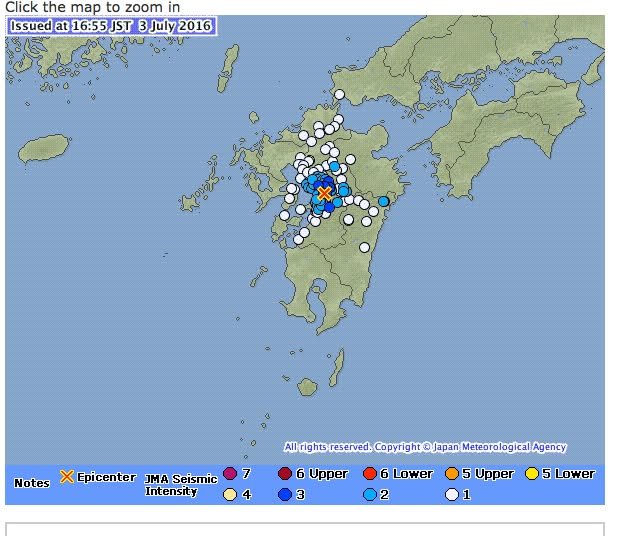
We just had an earthquake. The highest level reported on the JMA site was 3. The magnitude was 3.9. -- Kirk http://www.jma.go.jp/en/quake/6/20160703165533495-031651.html
3916
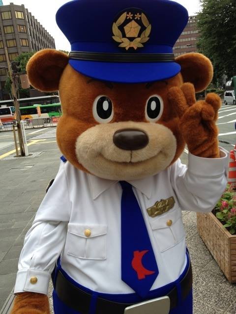
Yesterday, I attended a welcome party for foreign students at local universities. A police officer (not in uniform, as shown in the picture ;) ) attended and advised the students to call 110 if they were ever to need emergency help. He explained that even if there were a language problem the police would be able to identify the location from which you had made the call and send officers to assist you. So, if you were in a situation where you needed immediate assistance (e.g. you were injured in car accident, were the victim of a crime, stranded as a result of a natural disaster, etc.), merely calling 110 and saying "Help me" would be enough. -- Kirk
Here's some information from the Kumamoto YWCA about a Summer Program for KIDS that will be held on July 17th (Sunday). Thanks to Sayoko Ono for sharing this with us. -- Kirk
301
Faster internet would be nice . . . http://www.japantimes.co.jp/news/2016/07/01/business/broadband-get-faster-via-japan-oregon-cable/ Broadband to get faster via Japan-Oregon cable | The Japan Times An undersea cable backed by Google and Asian companies aimed at boosting trans-Pacific broadband was put into service on Thursday, the consortium announced
401
Here's another article about the retrial in a case that may prove to have been based on a coerced confession. -- Kirk http://www.asahi.com/ajw/articles/AJ201607010060.html Kumamoto man, 83, wins retrial after serving 13 years for murder:The Asahi Shimbun KUMAMOTO--With his frail body in a wheelchair and his mind wracked with dementia, a teary-eyed Koki
The link below is to a site which contains Youtube clips of 25 movies or commercials which take place in Kumamoto, starting from an "Otoko ha Tsurai" view of Amakusa back in 1973 (that's the only one I've watched so far, but it was very entertaining). Locations are written in Japanese under each clip. That they'd neglected to include the time Godzilla ate the former Kotsu Center is amazing; I'll try to find the video and post it below later. - William http://kumamo.jp/post-375/ 熊本はロケ地の宝庫だった!熊本が舞台やロケ地になった映画25本! | クマモ 熊本出身の映画監督、行定勲監督の熊本を舞台にした短編映画「うつくしいひと」が震災前の熊本の美しい姿を写したショートフィルムとして再評価されていますね。 そこで、今回は熊本を舞台にした映画を紹介します。
703
If you're a budding chef with a penchant for Asian food, this store will be your number one location for sourcing international ingredients. Kumamoto's Asian Food Shop (located on Route 3) is a treasure trove of delicious dishes just waiting to happen, not to mention the ready-to-go food like frozen jiaozi (Chinese dumplings) and baozi (Chinese filled steamed buns). Support Local and cook yourself something delicious while you're at it! Thanks, - Celia http://promotekyushuproject.blogspot.jp/2016/07/kumamotos-asaian-food-shop.html Promote Kyushu Project: Kumamoto's Asian Food Shop
20
"'Mr. Miyata might have made up the story,' presiding Judge Yoshihisa Mizokuni said in the court decision, adding his confessions could have been the result of 'adjusting' to the views of investigators." Kumamoto has been the site of several cases involved confessions that were later shown to have been forced. The most famous is that of MENDA Sakae: "In 1983, after 80 judges had been involved in Menda’s half-a-lifetime of struggle, a court finally acknowledged the police had concealed his alibi that he was not at the scene of the crime. With that, Menda — by then 54 years old — became the first person to ever escape Japan’s death row (three others, all tortured into confessing, have since been released)." http://www.japantimes.co.jp/life/2007/04/08/to-be-sorted/one-who-has-lived-to-tell-the-tale/ -- Kirk http://www.japantimes.co.jp/news/2016/06/30/national/crime-legal/court-retry-man-convicted-1985-kumamoto-murder/ Court to retry man convicted of 1985 Kumamoto murder | The Japan Times The Kumamoto District Court on Thursday decided to retry an 83-year-old man who served a prison term for fatally stabbing an acquaintance in 1985. The cour
40
Claims paid for Kumamoto Prefecture quake 317 billion yen to date The General Insurance Association of Japan (GIAJ) reports that claims paid in the wake of the Kumamoto earthquake in mid-April totalled 317 billion yen, or about US$3.1 billion, as of June 20. Specifically, there have been 239,749 inquiries made, 222,981…
403
After the quakes, Minami Aso in April set up a program called "empty house bank" in order to utilize the unused residences and vacation homes in the area to house locals whose homes are uninhabitable. In particular is an urge to prevent "people drain," wherein locals flee temporarily only never to return. Houses available for immediate occupancy are most sought, but those needing repair can be aided by a 30% subsidy of up to 6 million yen. House loan agreements are up to two years with a possible purchase option following. Unfortunately, only one property has registered to date. The village is renewing its call for owners of under-utilized property as well as for local residents who are interested in taking advantage of it to register by calling the following number: 0967(67)2230 Any on this site who know people with property in the area might want to let them know of the existence of this program. - William http://this.kiji.is/121070314055370237?c=92619697908483575 みなし仮設に利用 空き家、空き別荘登録呼びかけ 南阿蘇村 - 熊本日日新聞 熊本県南阿蘇村が、4月から始めた「空き家バンク」への空き家や空き別荘の登録を呼び掛けている。熊本地震の被災者に、みなし仮設住宅として利用してもらい、人口流出の抑制につなげたい考えだ。 入居の対象は住宅が半壊以上の被害を受けた人などで、村...
1704
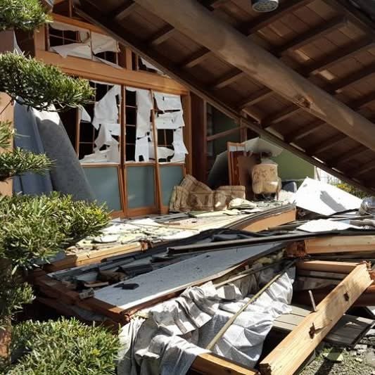
The weather has cleared up in Kumamoto. Unless I am unaware of some major development, Kumamoto did not suffer a serious setback in the last 24 hours. Unfortunately, the same can not be said for some other areas in Kyushu. The following video is of house in Nagasaki City at the moment of its collapse. -- Kirk https://www.youtube.com/watch?v=T8vZVR-BrUk 長崎市内住宅 轟音とともに崩壊 2016年6月30日木曜日 長崎市内の住宅が崩壊
Here's a little video that reminds us that Kumamoto is not all doom and gloom. This time-lapse video was recorded this past Sunday at Okoshiki Beach by my friend, Jim Reitz. -- KIrk https://vimeo.com/172747119 Okoshiki Beach, Japan The receding tide leaves behind beautiful sand bar patterns in southern Japan.
904
This video includes samples of a new movie, made with computer graphics, that shows what Kumamoto Castle looked like in the Edo period. -- Kirk http://www3.nhk.or.jp/news/html/20160622/k10010565301000.html
70
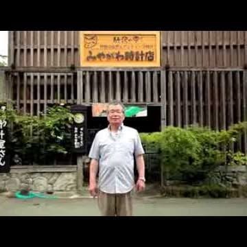
Sorry for the delay in sharing this . . . https://www.facebook.com/Kumamotoi/posts/10153818884688935 #2【みやがわ時計店 店主 宮川幸二さん】Kouji Miyagawa - Owner of Miyagawa Clock Shop- 阿蘇神社の参道にある仲町商店街。数多くある店の中で、一番阿蘇神社に近い場所で時計店を営む宮川幸二さん。本震のあった夜のことや商店街の話を伺いました。 The Nakamachi shopping street leads up to Aso Shrine.Among the other shops on the ...
30
Here's a post to Kumamoto International that was made several weeks ago. I regret having failed to share it. Click here to support KUMAMOTO EARTHQUAKE 59 RELIEF FUND by Shinri Endo Kumamoto Prefecture in southern Japan, was struck by a magnitude-7.3 earthquake on 16th April 2016, barely 24 hours after a previous shock of 6.5. The footage of the destructive power revealed the catastrophic events: toppled buildings and collapsed houses, the severely damaged Kumamoto Castle, a...
330
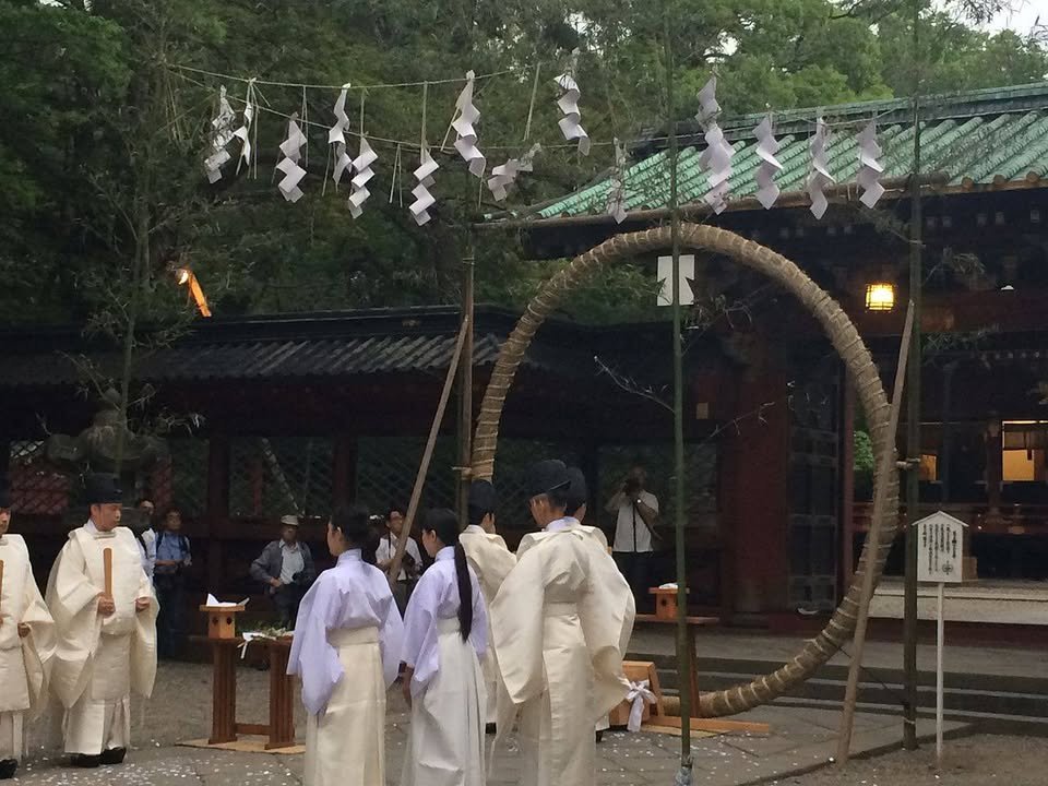
Thursday, June 30, is the Chinowa (茅の輪, cogon grass ring) Ceremony, a great chance to have more questions raised than you would likely ever want to have answered. For example, "cogon" is a type of grass traditionally used for thatching roofs. The maturity of cogon marked the entrance to summer, so this season was as good as any for a Shinto purification rite - this is why the ceremony is also called Natsugoshi Shinji (夏越神事, summer purification ceremony). Large rings of cogon (or, more generally today, easier to obtain materials such as bamboo) are set up at shrines, and worshipers must pass through the ring in a prescribed manner. The order I don't precisely remember - jump through the hoop, go left, jump through the hoop again, go right, jump through the hoop a final time and do something I've totally forgotten but if done incorrectly likely undoes all the previous hoop-jumping - yet even for those who hold no interest in Shinto, the ceremony clearly bears relevance for modern life: Jumping through hoops in just the prescribed way simply because everyone else is doing so and with no idea why. Visit your local shrine tomorrow so that you may ritually enact what for many of us is a major part of our actual lives - and feel pure after doing it for once. - William https://ja.wikipedia.org/wiki/%E5%A4%A7%E7%A5%93#.E5.A4.8F.E8.B6.8A.E3.81.AE.E7.A5.93.E3.81.AE.E9.A2.A8.E7.BF.92
90
I usually try to share messages posted to the page because, otherwise, I'm afraid that relatively few people will seem them. In this case, I simply failed to notice. Thanks to DO SHOCK BOOZE for your encouragement and support. -- Kirk CHITTODEN MUSIC ALBUM- Pray for Kyushu - ちーっとでん(少しでも) 地震・被災地の力になれますように。
733
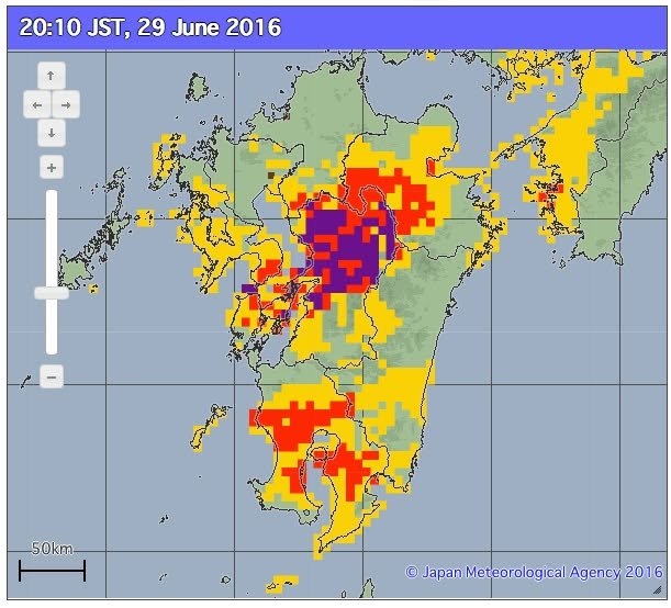
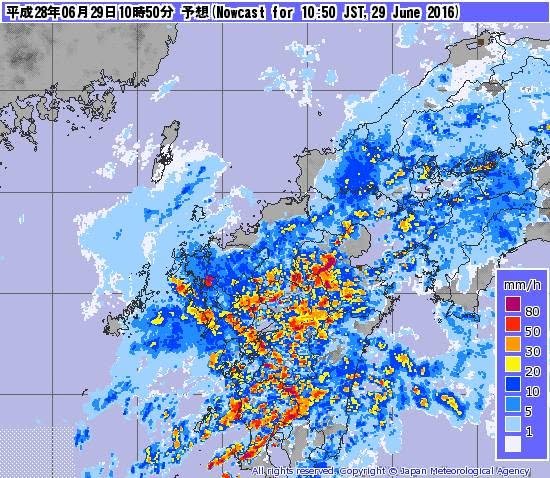
These images were taken from the Japan Meteorological Agency website: http://www.jma.go.jp/en/doshamesh/ Though the rain has subsided in many areas, more is on the way and, even without more rain, water-saturated slopes may be extremely unstable. Even if you do not live near a steep slope, you may want to think twice about driving on mountain roads if you can avoid doing so until the risk level declines. -- Kirk Tags: Landslide warnings, 土砂災害
201
Kumamoto earthquakes continue to have impact: Shortage on the way for older Sony cameras On Friday, Sony Japan released an update on the impact the Kumamoto earthquakes are having on their camera production. Sony is far from the only company impacted as Ricoh, Nikon and others have been affected by the devastating…
2473
Somewhere under all of that red is Kyushu. Heavy rain expected to continue through Thursday afternoon. Stay safe. -- William